Vashon Island Extreme
Yeah, it was pretty tough. Let me explain... 
I've wanted to do this ride for some time now. I finally got off my ass and did it. I took the 4:40 ferry from West Seattle to Vashon Island. The ferry ride is only about 15 minutes and I was on the bike just after 5pm. I let all the cars pass first and I think that's always a good idea even though bikers get off first. Once you're on the road, it's not pleasant to have a 100 cars whiz by. As it turned out, I saw very few cars afterwards, even less so than on Bainbridge Island because you can only access Vashion Island by ferry whereas Bainbridge is connected to the Olympic peninsula via a bridge.
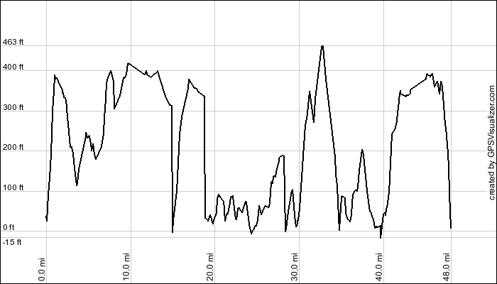
The ride at first was not very scenic at all. To make up for it, there were LOTS of hills. At the start, I was greeted by a 400 foot climb. From there, it was hill after hill. I actually didn't mind it at first but by about 35 miles I got pretty tired of it, but it was definitely a good mental (and physical) workout.
 The west side of the island is not very scenic unless you own a house by the water. There was a very nice view of southern Puget Sound at the bottom of the island which was about 15 miles in. When I got there there was a ferry leaving for Tacoma. The boat was very small, I've never seen one like it. I looked it up and it's called the M/V Rhododendron.
Once you get to the east side of the island, the views get much better, but they still don't match Bainbridge Island or the San Juans. Now if you look at the map you'll see Maury Island to the east of Vashon Island. I didn't know it was a separate island until just a minute ago because the crossing was a small bridge and I don't recall seeing a sign. It was just as hilly there if not more so. At one point, I could see downtown Seattle.
Well, that's that. I think I'll do this ride again beause it's really good training, but it's one of those rides that's more fun with someone else. BTW, GPS Visualizer has an elevation profile input form and I used it for the first time today. Previously I just used my Forerunner Logbook software for it. They're not that different but neither one gives you the total elevation gain/loss. I did some research on the Web and found that Motion Based does exactly that plus a lot more (detailed statistics and many maps in one place). I set up a free account and uploaded this ride and the most recent one on Bainbridge Island. It turns out the total elevation gain for Vashon was +3120 feet (total elevation change of 6240 ft.); Bainbridge was +2556.
Total: 48.4mi Bike Ride (total time: 2:58:38; avg. speed: 16.3mph)

I've wanted to do this ride for some time now. I finally got off my ass and did it. I took the 4:40 ferry from West Seattle to Vashon Island. The ferry ride is only about 15 minutes and I was on the bike just after 5pm. I let all the cars pass first and I think that's always a good idea even though bikers get off first. Once you're on the road, it's not pleasant to have a 100 cars whiz by. As it turned out, I saw very few cars afterwards, even less so than on Bainbridge Island because you can only access Vashion Island by ferry whereas Bainbridge is connected to the Olympic peninsula via a bridge.
The ride at first was not very scenic at all. To make up for it, there were LOTS of hills. At the start, I was greeted by a 400 foot climb. From there, it was hill after hill. I actually didn't mind it at first but by about 35 miles I got pretty tired of it, but it was definitely a good mental (and physical) workout.
 The west side of the island is not very scenic unless you own a house by the water. There was a very nice view of southern Puget Sound at the bottom of the island which was about 15 miles in. When I got there there was a ferry leaving for Tacoma. The boat was very small, I've never seen one like it. I looked it up and it's called the M/V Rhododendron.
Once you get to the east side of the island, the views get much better, but they still don't match Bainbridge Island or the San Juans. Now if you look at the map you'll see Maury Island to the east of Vashon Island. I didn't know it was a separate island until just a minute ago because the crossing was a small bridge and I don't recall seeing a sign. It was just as hilly there if not more so. At one point, I could see downtown Seattle.
Well, that's that. I think I'll do this ride again beause it's really good training, but it's one of those rides that's more fun with someone else. BTW, GPS Visualizer has an elevation profile input form and I used it for the first time today. Previously I just used my Forerunner Logbook software for it. They're not that different but neither one gives you the total elevation gain/loss. I did some research on the Web and found that Motion Based does exactly that plus a lot more (detailed statistics and many maps in one place). I set up a free account and uploaded this ride and the most recent one on Bainbridge Island. It turns out the total elevation gain for Vashon was +3120 feet (total elevation change of 6240 ft.); Bainbridge was +2556.
Total: 48.4mi Bike Ride (total time: 2:58:38; avg. speed: 16.3mph)
posted by Severe Training at 12:11 AM
![]()
![]()
0 Comments:
Post a Comment
<< Home