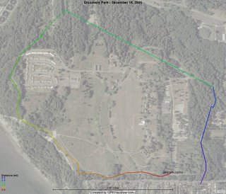
I haven't run the Discovery Park Loop in a while. Sometimes, I've called the ~14 mi. bike ride that goes through there (Belltown-Elliot Bay-Magnolia-Discovery Park-Ballard-Fremont-Belltown) by the same name. But this workout is about a 2.9 mile loop that goes exclusively through the park. I checked the Forerunner Logbook with my GPS entries and it looks like the last time I ran it was on May 22nd, before I started this blog. I don't run it that often because I have to drive there vs. just running straight from my place which I do almost all the time.
 In any case, it's a beautiful route that, if you park in the south parking lot, starts out with incredible views of Puget Sound and the Olympic Mountains. The edge of the park is on a cliff, so you get to see the sound from about a 300 foot elevation right above it. The cliff is on the southwest corner of the map. The route then goes through mostly forested areas which are still green even in the winter because of the evergreens and plants. However, many other trees are deciduous, so the tree cover is much more sparse than in the spring. Back then, I remember having some problems with the GPS signal when running through those areas. But I wasn't expecting it today. I think I know the solution however - I should have turned the watch just a bit on my wrist so that it was facing up a bit more (the watch does make a beep when the signal is lost). The result was that I lost coverage for just less than a mile I think. That's where the line is straight on the map and towards the end as well because the start and the finish are in different places.
I started out at a regular 7:30 pace but started running faster almost right away. I find myself often running a lot faster on dirt roads and trails than on asphalt. The sound made is so much different -- it's louder, which makes me want to go faster, probably because the louder sound itself creates an illusion of going faster. I compare it to a horde of horses running by you. Pretty inspirational, isn't it?
Total: 2.91mi Run (6:48 pace); 213 cal.; 142 lb.

0 Comments:
Post a Comment
<< Home